

The Willamette River is something that many of us from the Portland area are very familiar with, as it is a basic part of the downtown PDX experience. Many of us in the Portland area are also at least somewhat familiar with Willamette Falls, if only through pictures from those who have visited them locally. But there is so much more to the story of the Willamette River that caught our attention and we wanted to share it with you.
The fact is, there are a lot of pretty cool things about the Willamette River that you are likely not aware of. We did some research and took some amazing video to piece together the story of the Willamette River for you. Here’s a brief visual perspective of the Willamette River that will take your breath away.
Where Is The Willamette River?
The answer to where’s the Willamette River is a long story, literally. Starting just South of Springfield, Oregon, the mouth of the Willamette begins as a few waters converge just off Interstate 5, near Dorris Ranch. From the lookout of the headwaters of the Willamette at Dorris Ranch, you see the Coastal Fork Willamette River and the Middle Fork Willamette River joining to become the actual Willamette River.
*You see this from an aerial point of view at the beginning of the above video. It is quite impressive.
Dorris Ranch is not only a public park with trails that lead to the headwaters of the Willamette River, it is also working farm and a National Historic Site. When you park your vehicle and begin the nearly mile long walking trail that leads to actual location where the Coastal Fork Willamette River and the Middle Fork Willamette Rivers come together to become the Willamette River, you end up at a viewpoint that gives you a display of this majestic place that will leave you in awe. If the trail winding through walnut and filbert groves aren’t beautiful enough, the scenic lookout on the river’s edge will call you to take a seat at the picnic table and just observe the convergence of beauty and power.

The Path Of The Willamette River
Which city lies along the Willamette River? There are so many cities on or near the path of the Willamette river, more so than many even realize. The course of the Willamette river begins as it cuts through Springfield, to Eugene and proceeds North past Harrisburg, all the way through Corvallis, Albany and Oregon’s capital city of Salem. Continuing North, the river touches the South end of Newberg, then heads East through Wilsonville, before turning North again through Oregon City, West Linn and Lake Oswego. Finally the course of the Willamette River winds its way through downtown Portland before ending its journey by dumping into the Columbia River just East of the I5 freeway.
Willamette River Map
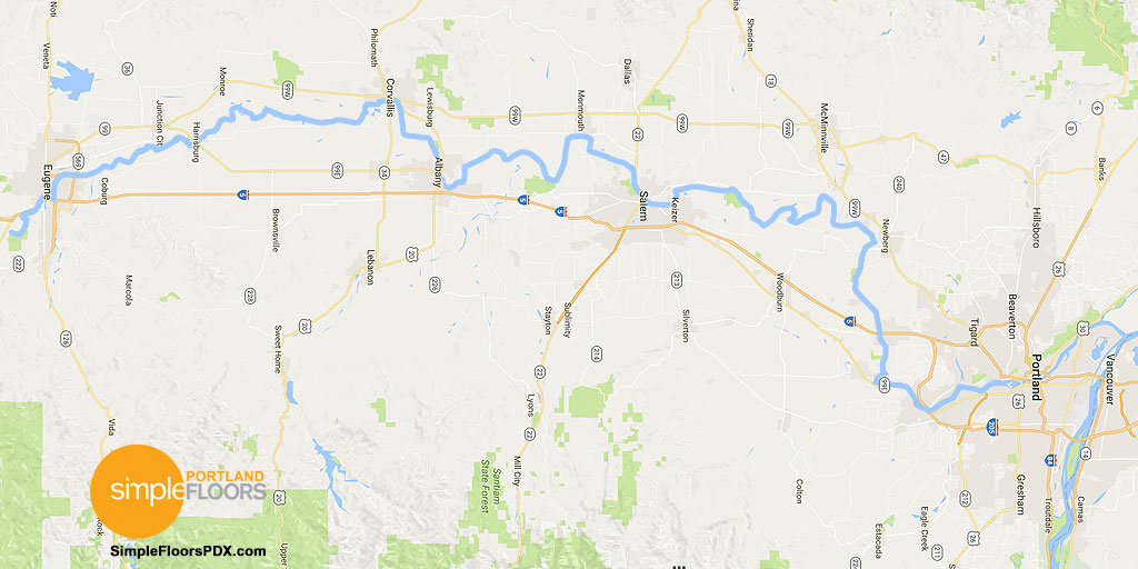 Here is a detailed Willamette river map that spans over half of the State of Oregon running South to North. We took the liberty to highlight and over accentuate the river’s course to make it easier to follow as it winds north through the State.
Map of Willamette River:
So where is the Willamette River becomes a complex question when you realize that this amazing river isn’t just something connected to Portland. The Willamette river course travels 187 miles in length, which is over half of the North to South distance of the State of Oregon itself, at some 295 miles. But what is really interesting is that the Willamette River runs northward, which is rare for such a long river. In fact, the Willamette is the longest river in the United States that flows uphill, primarily North.
When you combine the Willamette River length with that of its its middle and coast forks, the entire length grows to a staggering 255 miles in length, starting all the way down in Cottage Grove.
Activity Opportunities On The Willamette River
Being such a large and lengthy river, the Willamette offers numerous activity opportunities along its entirety. Whether you are looking for Willamette river fishing options, paths, parks, camping or boating, the Willamette offers numerous possibilities. We discovered that you can easily find the location for the following activities using the Willamette River Water Trail Destination Map.
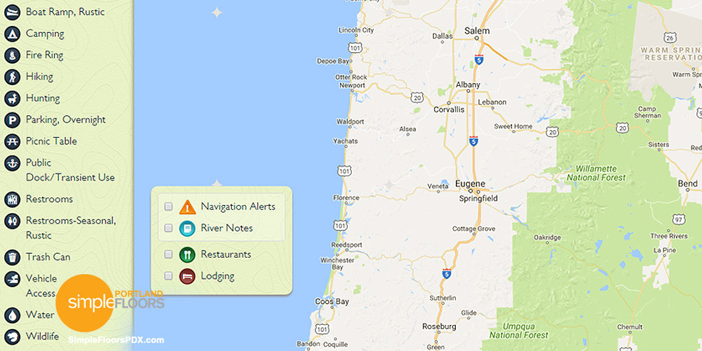 The interactive Willamette River map allows you to toggle and select various activities that you would like to locate along the length of the river. By selecting the various check boxes next to each activity type, the map will immediately update where those specific activities can be done on the river.
Some of the Willamette River activities that are available are:
Boat Ramps – Camping Spots – Fire Pit/Ring – Hiking Trails – Hunting – Parking, Overnight – Picnic Tables – Restrooms – Vehicle Access and Parking – Wildlife and more!
The Willamette River is not one of the mightiest or fiercest of rivers, but it is one of the most unusual. As Portlanders, we often see the Willamette as part of the downtown Portland culture and can easily miss the truly amazing aspects the river has to offer. When you begin to realize just how massive and unique the Willamette is, your appreciation for its impact on our State and the numerous communities it touches comes into plain view. The Willamette isn’t just a downtown Portland river, but one that merely graces our metropolitan area with its majestic fresh waters that are transported from the more southern reaches of Oregon.


The willamette river actually starts east above the Hillscreek damn & reservoir @ lake Tibanogus…FYI